









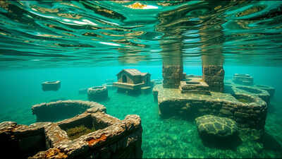
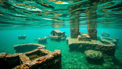
Beneath the still waters of Dicle Dam Lake in southeastern Turkey, an entire neighbourhood of stone houses, a mosque, a religious school and rock-cut tombs has sat largely undisturbed since the reservoir was filled nearly three decades ago. In recent months, a mechanical failure in one of the dam’s floodgates, combined with unusually heavy rainfall, caused water levels to drop sharply, exposing the submerged settlement clearly enough for researchers from Dicle University to carry out the first detailed underwater documentation of the site since the dam was completed. What they found was a settlement remarkably intact after decades underwater, offering an unusually clear window into a corner of southeastern Turkey that has been continuously inhabited for thousands of years.
Why the site was hidden underwater in the first place
The submerged settlement sits within the Eğil district, located roughly 52 kilometres from the centre of Diyarbakır in southeastern Turkey. According to Professor İrfan Yıldız, dean of the Faculty of Art and Design at Dicle University, speaking to NTV, construction of the Dicle Dam began in 1986, and once the reservoir was completed and began holding water, several historic neighbourhoods along the banks of the Tigris River were submerged. Yıldız specifically named the Tekke and Hacıyan neighbourhoods as having been most affected, noting that the Tekke neighbourhood contained a significant number of historic structures, including a mosque associated with the prophet Elyesa, along with the adjoining religious school known as the Caferiye or Lala Kasım Medresesi, a cemetery, and rock-cut tombs, most of which ended up beneath the reservoir’s waters. The tombs of the prophets Elyesa and Zülkifl, whose namesake structures once stood in Tekke and the nearby Hacıyan neighbourhood, were relocated to Nebi Harun Hill in 1995 specifically to spare them from the rising water, even as the surrounding mosques, cemeteries and rock cut tombs were left behind and submerged.”According to Yıldız, Eğil’s history stretches back to the Hurri-Mitanni period, with subsequent control passing through the Assyrians, Urartians, Medes, Persians, Romans and Byzantines before the region came under Islamic rule after the year 639, making it one of the more continuously significant settlement sites in the wider region for millennia before the dam was ever built.
What actually caused the water to drop this time
Unlike previous instances of exposed ruins in Turkey that have been linked to prolonged drought lowering reservoir levels gradually, this particular exposure was triggered by a more sudden and mechanical cause. The water level drop was the result of heavy rainfall combined with a malfunction affecting one of the dam’s gates, rather than drought conditions, a detail that distinguishes this event from other recent cases of ancient sites emerging from shrinking reservoirs elsewhere in the region.Local reporting on the gate malfunction noted that authorities, including Turkey’s agriculture and forestry ministry and its environment and urbanisation ministry, closely monitored the situation at the time due to flood risk concerns downstream, even as the resulting drop in water level presented an unexpected opportunity for researchers to document the long submerged settlement in far greater detail than had previously been possible.
What researchers actually found once the water receded
Once the settlement became visible, researchers from Dicle University carried out both underwater and on-site fieldwork to properly document what remained. According to reporting on the team’s findings, this combined survey identified 78 individual houses, a historic mosque and religious school, and numerous ancient graves and rock-cut tombs across the exposed and partially exposed areas of the site. Among the structures specifically highlighted was the Deran Bath, a Byzantine-era bathhouse situated between the settlement’s ancient citadel and its cluster of prophet tombs.Yıldız described the condition of the structures as extraordinary, noting that footage captured by the research team showed the buildings had preserved their structural integrity and remained standing in good condition despite having spent decades submerged. Researchers attributed this level of preservation to the relatively undisturbed, low-oxygen conditions created by prolonged submersion, which appear to have slowed the kind of decay that would typically affect exposed stone structures left in open air for a comparable length of time.
Why researchers see this as a rare archaeological opportunity
For archaeologists working on underwater and submerged heritage sites, an event like this offers a genuinely uncommon research opportunity. Rather than excavating a site buried and compacted under soil, as is typical in most archaeological digs, researchers were instead able to observe a settlement that had essentially been paused in place by the reservoir’s water since the 1980s and 1990s, its layout, walls and individual structures still largely legible rather than collapsed or eroded beyond recognition.Experts involved in documenting the site have suggested that events like this could mark the beginning of a new phase of underwater archaeological interest in Turkey, one focused specifically on the numerous historic settlements submerged decades ago during the country’s major dam building era, many of which have likely never been surveyed in this level of detail since the water first rose over them.
What happens to the site now that water levels are recovering
Because the exposure was caused by a temporary mechanical and weather-related drop in water level rather than a permanent change, researchers understood from the outset that their window to document the site in this much detail would likely be limited. As water levels in the reservoir return toward normal, the settlement is expected to disappear back beneath the surface much as it has for most of the past three decades, leaving the recent underwater footage and on site survey as one of the only detailed scientific records that exists of the site in its current, well preserved state, at least until the next unusual drop in water level offers researchers another chance to look again.